 |
| Karina holds the receipt and shows off all the food we purchased at BJ's, doesn't it look healthy! |
We tested the GPSs, radar systems, ASD albedo measuring device, new laptops, satellite internet connection, satellite phones, and Karina's new Canada Goose jacket (all the old ones were way too large for her).
 |
| Gabe got some funny looks testing the satellite internet outside of the Earth Science building as class was just letting out |
Over the winter, Gabe worked on a paper calculating accumulation across the interior of the Greenland Ice Sheet based on airborne radar from NASA's Operation IceBridge. After publishing the study (link here) we realized there was a large gap between the coastal weather stations and regions where airborne radar could calculate accumulation. We decided to traverse through this gap to take the most useful measurements.
 |
| 2016 GreenTrACS traverse (blue) and 2017 route (red) on top of a NASA Operation IceBridge accumulation radar measurements |
Karina and Gabe will fly to Kangerlussuaq on 4/18 to prepare. On 4/25 Tate, HP, and Forrest will join in Kanger to prepare for the traverse. The entire team will fly to Summit on 5/1 and spend a few days acclimatizing and testing all the scientific gear in the very cold conditions.
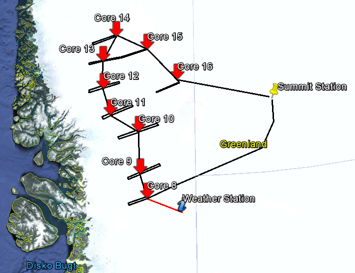 |
| A detailed view of the 2017 field traverse |
We'll spend a few days snowmobiling from Summit to Core 8, trying to maximize the radar data quality along this ~400 km section. Once we all reach Core 8 the real science begins. Karina and Gabe will drill their first ice core together, a team will drive west to collect radar measurements, and someone will return to Core 7 to collect the weather station we left there last season.
Bob will fly to Greenland April May 15 and join the rest of the team a few days afterwards. He will bring news from the states, fresh vegetables, and hopefully a birthday cake for Gabe! HP will then fly back to Idaho to resume his teaching and research responsibilities.
Just as last year it will take a few weeks to work out all the kinks and begin to click together as a team, but we are all looking forward to the science and opportunities we'll have this season.
No comments:
Post a Comment